
Revere Evacuation Zones
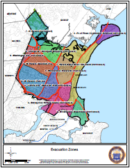 Please make note of your Evacuation Zone, or by visiting the City GIS page, and select the Map icon at the top right corner and select the "Evacuation Zones" map.”
Much as we hope to never have to use a fire exit or an insurance policy, there is a reason we have them. We very much hope to never have to utilize these routes, but it is an important part of emergency preparedness that all residents are aware of evacuation zones and routes. During a potential flood emergency, for instance during a hurricane or other high winds and rain during high tide, there may be a need to evacuate parts of the city. However what Emergency Officials have learned from these experiences elsewhere is if everyone tries to leave at once, the roads bottleneck and nobody can get out with any haste. That is why Revere Emergency Management Officials have been working in coordination with the Massachusetts Emergency Management Agency (MEMA) to develop Evacuation Zones and Evacuation Routes, so that specific neighborhoods that may be in danger can be cleared strategically and more quickly.