Ongoing Initiatives
Leach Park Community Meeting
September 6th @ 6:00PM
Join the Department of Planning and Community Development (DPCD) to learn more about the proposed updates to Leach Park. Meeting will be held at Leach Park (corner of Broadsound & Leverett Ave).
Proposed project plans
Proposed tree plantings
*Plans updated 9/7/2023
Gibson Park Resiliency & Recreation Project
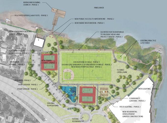
The City of Revere has undertaken a significant redevelopment project to reduce current and future threats from flooding and sea level rise in your Riverside Neighborhood. The Gibson Park Resiliency Project is aimed at providing nature-based resiliency measures to an area that has historically faced both tidal and storm flooding events. Beginning in 2020 with RiverFront Masterplan, the City has been working to reduce risk and redevelop the area around Gibson Park and Mills Avenue Neighborhood to improve resiliency and recreational opportunity. Specifically, the project produced four goals for the project: creating resiliency, serving the community, addressing historic high tide flooding, and cleaning up the environment. Future Project information and developments, including public meetings will be posted to the City Department of Planning and Community Development's website here. Questions can be addressed to Elle Baker.
Site Visit Notice (Spanish) (Arabic) (Khmer) (Portuguese)
Environmental Justice Screening Form (English) (Spanish) (Arabic) (Khmer) (Portuguese)
MEPA Filing
Certificate of the Secretary of Energy and Environmental Affairs on the Expanded Environmental Notification Form
Notice of Public Meeting (English) (Spanish)
Spanish translation will be offered via zoom. If you prefer in person translation during the meeting, please email Elle Baker at ebaker@revere.org before Monday October 16th at 5:00PM.
Public Forum Presentation October 18th, 2023
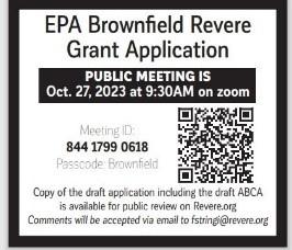
EPA Brownfields DRAFT Grant Application (Recorded Meeting Video)
MEPA
MEPA: EEA NO.:16711
The project consists of the redevelopment of Gibson Park into an up-to-date multi-program recreational facility incorporating nature-based interventions to protect the Riverside Neighborhood from current and future threats from flooding and sea level rise. Additionally, work along Mills Avenue includes the installation of a nature-based berm, updating the municipal stormwater system, and use of a pump station/sub-grade stormwater storage holding .
The DEIR can be viewed through the MEPA Environmental Monitor by clicking on ‘Attachments’ for the corresponding project: https://eeaonline.eea.state.ma.us/EEA/MEPA-eMonitor/home.
Please note that the Proponent has provided supplemental information in the form of a revised DEIR. The revised DEIR, including the narrative and the appendices is available via the dropbox link below:
https://www.dropbox.com/scl/fo/5qdcltv93dr8is1b72zqv/h?rlkey=yc21q3sfruvmag6sr8tl0j413&dl=0.
Resilient Bennington St & Fredericks Park, Boston/Revere
SUMMARY OF PROJECT SCOPE AND GOALS
- Conduct a feasibility assessment, preliminary schematic design, and permitting evaluation of three flood risk reduction alternatives;
- Identify a preferred alternative that will protect East Boston and Revere from the near- and long-term impacts of coastal flooding from sea-level rise and storms;
- Advance the preferred alternative into further schematic design;
- Ensure that the preferred alternative will support the health and longevity of Belle Isle Marsh;
- Ensure that the preferred alternative support co-benefits along Bennington Street, including green storm water infrastructure, tree canopy, and active transportation; and
- Redesign Fredericks Park to improve coastal resilience, storm water management, recreational amenities, and ecological habitat
Resilient Bennington St & Fredericks Park, Boston/Revere presentation and recording here.
Project Documents
Resilient Bennington Street and Fredericks Park | Boston.gov
Saugus River Watershed Regional Adaptation Planning

Flooding along Mills Ave. in Revere. Photo: Loretta Le Centra
The impacts of coastal storms, sea level rise, and other climate hazards are not beholden to City or Town borders. While the communities of Lynn, Revere, Saugus, Everett, and Malden are unique in their neighborhoods, cultures, and identities, they share the impacts of coastal hazards associated with the Saugus River Watershed. A regional problem requires regional partnerships and solutions. This is why these five communities along with state agencies MassDOT, Department of Conservation and Recreation, and the MBTA have come together to conduct a vulnerability study that will give the region a more holistic understanding of current and future coastal risk within the Saugus River Watershed.
Public Meeting for Flood Risk in the Saugus/Pines River Watershed
Regional Vulnerability and Adaption Study Recorded Presentation
Forum Takes a Close Look At Saugus River Watershed Flooding Risks
Understanding and Managing Risk
If you are a resident of one of the five Saugus River Watershed communities, you have likely already experienced the impacts of coastal hazards – whether that be flood damage to your home or property, disrupted transportation routes, or beach and coastal park closures. Risks associated with flooding, erosion, and storms are expected to be exacerbated by climate change and sea level rise. The main goals of the Coastal Vulnerability Assessment and Adaption Plan are to identify potential flooding impacts to public infrastructure and natural resources, provide data on likely future flooding scenarios, identify potential adaption strategies and funding sources to reduce risk, develop an economic impact assessment, and increase public outreach and education on coastal hazards and solutions.

Massachusetts Coast Flood Risk Model (MC-FRM) flood risk probabilities for the year 2070. The MC-FRM models the annual percent chance (probability) that a location will get wet with salt water during a coastal storm event. These probabilities each correspond to a color in the map legend.
MVP Project Documents FY 23 and FY24
https://lynnincommon.com/saugus-river-watershed-regional-adaptation-plan
Beachmont Fire Station Concept Plan
The City of Revere has identified a city-owned, decommissioned fire station as a potential facility to be repurposed as a community arts center and has engaged the MAPC Arts & Culture Department to provide technical assistance in a community visioning process. This process will culminate with a Concept Plan authored by MAPC to guide the successful and sustainable implementation of a community space, informed by a thoughtful and participatory community engagement process.
MAPC will work with the City of Revere to convene stakeholders, establish a Project Working Group and develop and employ a community engagement strategy to understand the community’s needs and priorities for new community space in the City. With guidance from the Project Working Group, MAPC will develop this engagement to solicit feedback that represents the diverse communities living and working in Revere. Complementing this insight, MAPC will explore relevant case studies and investigate relevant operating models to inform use and programming recommendations for a future center.
If you are interested in the potential uses of the Beachmont Fire Station, please complete our Community Survey.
Beachmont Fire Station Stakeholder Meeting Slides
City of Revere Hazard Mitigation Planning 2021
- Public Stakeholder Meeting #1
- Hazard Mitigation Fact Sheet
- Hazard Mitigation Plan
- Hazard Mitigation Presentation
- Presented for Adoption - Revere Hazard Mitigation Plan 2022
Coastal Resilience Feasibility Study for Riverside and Point of Pines - MVP Action Grant
The Point of Pines/Riverside Area Coastal Resiliency Feasibility Study is an integrated coastal protection initiative for the City of Revere. The study consists of six memorandums aimed to evaluate the flood vulnerability and potential mitigation options for the City.
Coastal Resilience Feasibility Study for Riverside and Point of Pines - Final
Revere is An MVP Community
Shirley Avenue
The Shirley Avenue district is a vital neighborhood commercial corridor that links Bell Circle and Revere Beach and provides connections to the MBTA’s Blue Line at Revere Beach Station. Shirley Avenue’s designation as one of the state’s Transformative Development Initiative (TDI) Districts in 2022 has leveraged substantial technical assistance along with public and private financing to support its ongoing revitalization. For more information on Shirley Avenue, read about it here.
Suffolk Downs
Located along the Revere-Boston border, this 161 acre former horse racing destination will be transformed into a series of transit-oriented, mixed use neighborhoods. With 51 acres in Revere, the site’s opportune location near two Blue Line MBTA stations will add substantially to the city’s housing stock, commercial and office space, and active recreational and open space. For more information on Suffolk Downs, read about HYM's mission to connect East Boston and Revere here.
Creative District
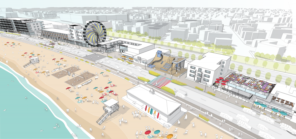
To complement investment along Waterfront Square, the City is planning for further redevelopment efforts along the southern section of Revere Beach between Eliot Circle and Shirley Avenue. This new Creative District will contribute to the ongoing revitalization of historic Revere Beach into an attractive and robust commercial and recreational destination for residents, visitors, and businesses alike.